Summary
- Construction and Extensions
- The Sentinels of Metro Line 6
- An elevated metro line
- Preserving heritage
- Glass canipy stations
- Things are moving along on metro line 6
- Why do trains stop for several minutes at Kleber station?
- Street art route
- The metal staircases at Cambronne station have been given a facelift!
- Ca vaut le détour !
Construction and Extensions
At the time the metro line 6 was built, it was called "2 sud" ("line 2 south"). In 1900, the Étoile – Trocadéro segment of the line served the World Expo, while construction works continued up to Place d’Italie, and the ambitious Seine River crossing at Passy station was built, and opened to the public on 5 November 1903.
On 24 April 1906, the line was extended up to Place d’Italie, where a new maintenance centre was built. In October 1907, the line was merged with metro line 5, which had opened in June 1906, absorbing as a result the former metro line 2 Sud. The new metro line 5, linking Étoile station to Gare du Nord station, was operated in that configuration until 1942. There also used to be a metro line 2 nord (north), known as metro line 2 today.
The line that was originally numbered 6 served a short segment from Place d’Italie to Nation stations, and was commissioned on 1 March 1909.
In 1931, to provide better services to that year’s Colonial Exhibition, metro line 6 was “extended”, by using metro line 5 tracks. Metro line 6 then ran along a semi-circular southern route from Nation station to Étoile station, its current path. Following the end of the exhibition, the City of Paris ordered the CMP (Compagnie du chemin de fer métropolitain de Paris, Paris metropolitan rail company) to resume its earlier operations, which the CMP did for 11 years.
It was only after the extension of metro line 5 to Pantin station on 6 October 1942, during the German Occupation, that the current configuration of metro lines 5 and 6 took shape. As such, metro line 5 linked Place d’Italie to Église de Pantin, while metro line 6 connected Étoile to Nation.
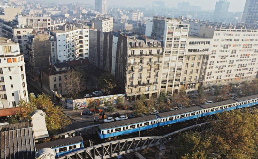
An elevated metro line
Similarly to metro line 2, part of metro line 6 was built above ground along the length of the Fermiers Généraux wall (former Paris city wall, which was demolished in 1860), thereby avoiding the need to bore tunnels. The viaducts that hold up the line’s tracks were erected above street level, according to the design laid out by architect Jean-Camille Formigé, by combining several construction techniques: brickwork, chiselled stone and metal structures worthy of major train stations. 
This gave rise to two unique viaducts that were built to cross the Seine – Passy in the west and Bercy in the east.
The Passy viaduct
Part of the 237-m structure, which was built in 1903 and completed in 1906, rests on Île aux Cygnes (Isle of Swans), a small artificial island on the Seine. The viaduct’s exceptional architecture comprises a metal deck, upon which the metro tracks are laid. Two 6.9-m high rows of slender rolled steel columns that hold up the desk showcase the sophistication and elegance of the viaduct, which has been listed as a historical monument since 1986. The remarkably ornate monumental structure was designed by Jean-Camille Formigé. Four bas-relief allegories adorn the stone structure on Île aux Cygnes, the viaduct’s central arch. They represent Science, Labour, Electricity and Commerce.
The Bercy viaduct
This 175-m long structure was built between 1905 and 1906, and flanked by 41 small stone-covered arches over its main arches. The Bercy bridge was built in three stages. The first 5-arch stone structure, which was to become the road on the Paris side of the bridge, was opened in 1864. The bridge was subsequently widened by 5.50 m in 1904 to accommodate the metro viaduct. In the 1990s, to ensure that either side of the viaduct had a road, the bridge was widened once more on the side facing the ring road, thereby surrounding metro line 6 with two roads. Although the extension was built out of concrete, it was paved over in stone to match the rest of the structure.
Preserving heritage
Metro line 6, like metro lines 2 and 5, is recognisable because of how its fittings (viaducts, pillars, arches, glass canopies, staircases, mezzanines and more) have remarkably stood the test of time. To guarantee the usability, visual appeal and durability of these lines, conservation works are scheduled every year, with renovation projects targeting certain stations or line segments. This is why works were conducted from 2014 to 2021, to maintain and repair the Passy viaduct.
Glass canipy stations
On metro line 6, platforms and tracks are sheltered under unique glass canopies. Platforms on the elevated segments of metro line 2 are protected by partial winged canopies.


